Mayas of Belize and Conservation: The Need to Protect Maya Lands in the. Toledo District
The Maya Indians owned and occupied by aboriginal right the territory that is now Belize for thousands of years before European settlement. Although there was no formal act of annexation or confiscation, British settlers and the colonial government in the nineteenth century gradually dispossessed the Mayas of most of their land. To provide a relatively unmolested home for the Mayas, the British government created a number of small reservations on Crown lands in the Toledo District for the Mayas between 1897 and 1933. Totaling about 76,000 acres, the reservations are home today to the great majority of Mayas in Belize, who continue to practice traditional milpa subsistence farming and some cash crop farming. In the Toledo District, the Maya communities are comprised of Mopan and Kekchi Maya. (See map showing the location of Maya villages in the Toledo District.)
Maya Homeland Proposed
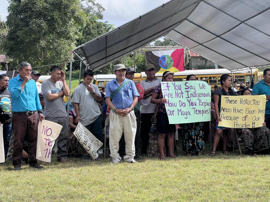
Today, the Mayas in the Toledo District are facing grave threats to their land and traditional way of life. The Toledo District is increasingly viewed by foreign investors are fertile ground for the development of commercial plantation farming and forestry extraction. There are credible reports that the government is considering an application from a Malaysian company for a license to cut mahogany and cedar in large areas of the Toledo District. Last year, the government tried to privatize the reservations by dividing them into allotments and inducing Maya farmers to pledge the parcels as collateral for agricultural loans. Immigration and rising birth rates are also putting new pressures on the Maya land base. The Mayas are also rightly concerned that their rights to use and live on the reservations are not adequately protected under Belize law. For these reasons, Mayas have proposed that a territory of 500,000 acres in the Toledo District be set aside as a Maya homeland, fully protected and preserved under Belize law. This proposal has been put forward by the Toledo Maya Cultural Council and others working on land protection and natural resources management from the Maya perspective. The Mayas have always been good stewards of the land, in keeping with their strongly-held belief that all persons should live in harmony with their environment. Maya values require the almost respect for the land and the natural world. At the same time, the Maya communities rely on the land for the subsistence farming which provides most of their daily food and other resources. Because of their dependency on the land, the Maya communities believe that their new homeland must be ecologically protected, in order to ensure that the land and natural resources are preserved for future generations. * Unparalleled Natural Diversity The need to control development and preserve the natural areas of the Maya land is even more compelling when the unique ecological characteristics of the area are considered. Belize is a country of almost unparalleled natural diversity, rich in tropical and subtropical ecosystem, yet extremely vulnerable to destruction by development. Belize is in an excellent position to preserve its natural resources because the country is sparsely populated, and environmental destruction has not been widespread. Belize is perhaps the last remaining country in Central America where the primary forest cover is intact in large areas because it is not experiencing widespread forest destruction. There are several areas that have been deforested; however, in areas where deforestation is occurring, it is at a relatively slow rate. Many species that are endangered or threatened in other countries are still abundant in Belize. Belize's forests and natural areas are home to relatively large populations of Baird's tapirs, ocelots, iguanas, crocodiles, cougars, howler monkeys, brocker deer, otter, margay, jaguars, puma and jaguarundi. Belize is also home to rare birds such as the Ocellated Turkey, American Sungrebe, Solitary Eagle and Orange-breasted Falcon. Over 500 species of fauna have been identified. Belize's coasts contain some of the finest mangrove forests in the world. The barrier reef is the second longest in the world. Belize is thought to have the largest population of manatees in the world except for the United States. Green hawksbill and loggerhead turtles are still plentiful, although they are harvested for local consumption. The coastal plan savannahs are home to the Jabiru stork, the largest of American flying birds. The country is estimated to have over 4,000 species of native flowering plants, including 250 species of orchids and 700 species of native trees. Sound Forest Management It is no accident that the Toledo District, where most of the Mayas live, is one of the most pristine areas of Belize. Ancient Maya who inhabited the area managed the forests and lands through the swidden or milpa system of subsistence agriculture. If properly managed, the milpa system is an efficient and environmentally sound method for producing food while maintaining healthy and diverse ecosystems. As one recent study concluded, "[s] widden cultivation, as practiced by Amerindians with short cropping and long fallows, is considered a relatively benign disturbance, ad it does not seriously impair ecosystem function." In fact, recent evidence suggests that many of the pristine areas in Central America today are the result of forest management practices by Indians. Much of what is thought to be virgin forest today was farmed by Indian people using the swidden method hundreds of years ago. The areas of Indian occupation largely coincide with the areas where the natural forest and vegetation are still intact. The Mayas today continue to practice milpa agriculture, yet the Toledo District contains natural areas, rainforest and wildlands that have significant ecological value. There is no full-scale ecological inventory of these areas, but there are several studies which underscore their unique ecological character. The information which follows is taken from these studies, which are referenced in the Further Reading section at the end of this article. The Toledo District is ecologically unique in Belize and perhaps in all of Central America. It has seven major rivers, thousands of acres of forests and rugged mountains, unique formations of steep or limestone topography and thousands of acres of coastal plain. A study by the Belize Center for Environmental Studies (BCES) found that the evergreen forests of southern Belize, particularly those in the Toledo District, are the most species-rich in the entire country. In the southern part of the Toledo District, there is a tropical forest ecosystem that contains cotton trees which sometimes reach 50 meters in height, and extensive freshwater swamps where the largest population of comfray palms anywhere in Belize is found. From Big Creek south to Golden Stream along the coast, the Toledo District contains pine forests and savannahs that support thriving populations of the endangered or threatened black howler monkeys, jaguars, and tapirs. Crocodiles inhabit freshwater ponds. From a conservation perspective, the Toledo District can be divided into four separate ecosystems: the Maya Mountains, the Limestone Hills, the Toledo Beds and Coastal Plain. These areas are differentiated by rainfall, vegetation, and land forms. 1 Maya Mountains. This area is a rugged forest wilderness which, except for selective logging in the lower slopes, is relatively untouched. The poor soils and steep slopes make it inappropriate for agriculture, and extremely susceptible to erosion. Most of this area has been placed in forest reserve status by the Belize government. This does not mean that the area is in a protected conservation status, but rather that it is permanently dedicated to forestry activities, including logging. The vegetation of this area is classified as the ecological life zone, "sub-tropical lower montane wet." 2 Limestone Hills. This area lies south of the Maya Mountains and southwest of the Maya village of Aquacate. Portions of it have been farmed by Mayas for generations. As with most limestone topography, the area contains numerous caves and sinkholes. The vegetation is classified as sub-tropical to tropical wet. There has been some deforestation due to milpa farming, but in the steep, inaccessible areas, the forest cover is intact. The tree species include chicle macho, cherry, ramon, cedar and fiddlewood. 3 Toledo Beds. This ecosystem is drained by the Sarstoon, Temash and Moho Rivers. The forests of this region are evergreen seasonal forests. Large parts of the area are farmed by Mayas under the milpa system. Rainfall annually is very high, upwards of 160 inches in some areas. 4 Coastal Plains. This area consists primarily of pine forests and savannah grasslands running from Big Creek in the north to Deep River in the south. Most of the land is flat to gently undulating with a few limestone hills. It is especially important ecologically because of a number of wetlands and swamps with great species diversity. Habitats in Urgent Need of Preservation In 1990, the Belize Center for Environmental Studies (BCES) identified a number of natural areas within Belize that contain critical habitats in urgent need of preservation. A number of these important areas are within the Toledo District and the proposed homeland for the Maya communities. Perhaps the most important of these is the area between the Sarstoon and Temash Rivers in the far southeast corner of the Toledo District. The report describes this area as the "least disturbed wildlands area in Belize." This area contains probably the finest Red mangrove forest anywhere in Belize. It is extremely rich in habitat, species, and biological diversity. Rare terrestrial species found there include the Howler Monkey, all five species of Cats, Morelet's Crocodile and the Ornate Hawk Eagle. The area is also ecologically significant because it contains the most abundant habitat for the Comfray Palm found anywhere in Belize. The area is a short distance from the Maya village of Crique Sarco. In December, 1992, the Government of Belize established the Temash Nature Reserve in this area. The Maya people were apparently not consulted about its creation. Another critical habitat site is the Aquacaliente Swamp and Laguna Hills area which borders on the Black Creek Indian Reservation. It is a biologically diverse habitat of swamp and forests which is home to the Jabiru Stork and Tapir. The Laguna Hills contain Maya caves and minor ceremonial sites, which have been damaged by looting. The Columbia Forest Reserve in the Maya Mountains is also on the critical habitatlist. The reserve is approximately 103,000 acres of tropical forest, which is not currently in protected status under Belize law. Forest reserves are created for wood exploitation rather than wildlands conservation. Nevertheless, almost all of the reserve's forest cover is intact. BCES found that the Columbia Forest Reserve has "unique ecological features" not found elsewhere in Central America, due to the richness of its tree species. It is one of the few ecosystems of its type found anywhere in Belize or Central America. The forest provides important watershed protection to the farms along the Columbia and Rio Grande Rivers. During a week-long observation trip into the forest in 1990, 135 species of birds were documented. Included on this list were the Yellow-faced Grassquit, which had been sighted only one other time in Belize; the Common Woodnymph, which had not previously been recorded in Belize; and the Orchard Oriole, which is the only effective pollinator of the abundant tree Erythrina Fusca. The Slate-colored Solitaire, not found anywhere else in Belize, has also been observed in the forest. It is also possible that the extremely rare Harpy Eagle may inhabit this area. It is thought to breed along the main divide of the Maya Mountains in the Stann Creek and Toledo Districts, but there have only been a few sighting in the last 20 years. The Checklist of the Binds of Belize indicates that it inhabits only the southern part of the country. The flowers and wildlife are also richly diverse in the Cloumbia Forst Reserve, Exotic palms, cycads and orchids are found is abundance. Rare animal species include Baird's Tapir, Collared Peccary, jaguar, ocealor, jaguarundi and Black Howler Monkey. The Cloumbia Forest Reserve contains several Maya caves and burial grounds. The 1990 expedition explored several of these, including U-Artun-Jale, (Gibnut's cave); and Actunil-Cha-Hun (Youth's Cave). Also discovered was a Maya ceremonial center known as Ich M' K' hil or Wild Cacao Plants. Several of these sites had been looted. There are likely other caves and rivers yet to be discovered and explored. The Belize Ministry of Natural Resources has drafted a forest management plan for the Columbia Forest Reserve. The goal of the plan is the conservation of the forest and the establishment of sustainable forestry management practices. The Toledo Maya Cultural Council has raised concerns about the plan's forestry extraction components and the benefits for the local communities. This brief survey makes a compelling case for the preservation of significant portions of the Toledo District. There is only one nature preserve fully protected under Belize law in the Toledo District, one of 15 such reserves in Belize. The Bladen Nature Reserve was created in 1989 from an ecologically diverse area north of the Bladen Branch of the Monkey River. It is an area of largely undisturbed wilderness, approximately 100,000 acres in size, and managed by the Belize Audubon Society. The Nature Conservancy is presently conducting an assessment of the species found in the reserve, in conjunction with the Belize Audubon Society and the Programme for Belize. More Studies Needed for Effective Conservation The surveys which are summarized here are a good beginning to understanding the ecological significance of the natural areas of the Toledo District. They provide a solid basis for further investigation and study. Most of the information about the plants and wildlife in the Toledo District is fragmentary, however. Much more information will be needed before conservation planning and management can be effectively carried out. Only a small amount of information has been collected thus far from visits to the area. Most of the studies rely on written sources compiled several years ago. None of the existing studies contain complete and specific information about the ecological characteristics of the Indian reservations and the Indian villages in the Toledo District. Nor is there adequate information about land-use patterns, plant and animal species, and human activities in the proposed Maya homeland. Most of the studies focus broadly on areas which are the most sparsely inhabited. To fill this gap, the Maya communities, with the help of the Indian Law Resource Center and the Center for the Support of Native Lands has devised a plan to prepare a land-use map of Indian reservations of the Toledo District. Drawing on the experience of Indian communities in Honduras and Panama, the Toledo Maya Cultural Council plans to prepare a detailed map of where the Maya people live and how they use their land. Land-use mapping by Indian communities has proven to be a valuable tool in the ongoing efforts to establish legally protected Indian homelands in Central America. Mapping of Indian lands also helps ensure that Indian communities are fully integrated into conservation management and planning. The Maya communities, which are the caretakers of much of this land, must be fully integrated into the planning and management process, if effective conservation is to be achieved. Too often in the past, conservation is to be achieved. Too often in the past, conservation is to be achieved. Too often in the past, conservation projects which affect Indian lands have been designed and implemented without meaningful input from the Indian communities. This "top-down" approach to conservation management had excluded Indian people who have, in many cases, managed the land in an environmentally sound manner for generations. An important and valuable source of knowledge about the natural world and how to manage it in a sustainable manner is lost when Indian people are excluded from conservation projects. To be sure, Indian people rely on the natural world for the plants and animals they need to live full, productive lives. Like other peoples, they must develop and manage their territories to produce food, shelter, clothing and the other necessities of life. Indian people have been practicing sustainable development for hundreds of years before that term became fashionable in the environmental community. It is because Indian people are tired to the earth in this life-sustaining way that they are responsible managers of natural areas. Indian management of natural areas, based on reverence and respect for land and natural resources, has contributed to the conservation of thousands of acres of biodiverse environments in Belize and throughout the world. As they work to strengthen legan protection for their homeland, the Maya of Belize are carrying forward this proud tradition for their future generations, for all of Belize, and for the general benefit of humankind. Article copyright Cultural Survival, Inc.