Defending the Miskito Reefs with Maps and GPS: Mapping With Sail, Scuba,. and Satellite
On the far western edge of the Caribbean, within the wide marine shallows of coral, sand and seagrass, in the communal sea territory of indigenous coastal communities, Miskito "captain" - the traditional sea knowledge specialists - are working with invited marine scientists, Miskito environmentalists and lobster divers to map the Miskito Reefs and surrounding waters. The Miskito Reef Mapping Project is being done by the communities for three reasons; 1) to document that these vast waters and reefs are theirs; 2) to justify community defense of their sea territory against international lobster pirates, drug traffickers, and industrial fishing fleets; and 3) to provide baseline geographic and biological information for future comparison of coral reef diversity and health. This community-based mapping project combines the sophisticated traditional geographic knowledge and first-hand experience of the Miskito sailing captains, green turtle fishers, and lobster diverse, with the accessible, accurate and affordable mapping technology of GPS, Hi-8 video, laptop computers and GIS software brought and taught by the invited marine geographers and marine biologists. On board 34-foot sailing canoes, the captains and the scientists criss-cross the reefs, mapping underwater topography with traditional Miskito names and GPS lat-log, locations. Underwater video and 35mm cameras are used to record marine habitat and species composition and status for later review and identification in the communities. Sometimes the video and 35-mm cameras and GPS are used to record the presence and location of heavily-armed Honduran lobster "pirates", Colombian drug traffickers, and Nicaraguan and U.S. industrial fishing vessels that operate illegally within traditional Miskito sea territory and the new Miskito Cays Protected Area.
To defend their sea territory against these intrusions, the Miskito communities decided that first it would be necessary to demonstrated that the sea territory and its resources were indeed theirs. This is why the communities are using sail, scuba and satellite to map and inventory their reefs and waters in their language and in their traditional knowledge classifications. The sea region to be mapped is approximately 4500 square miles (11,600 km2) - which is equivalent to the land area of Jamaica, one-half of Belize, or larger than Puerto Rico.
THE POST-WAR ASSAULT ON THE MISKITO REEFS
By 1990, after this 11th successful armed resistance against outside invaders in the last 400 years, the Miskito and others Caribbean Coast peoples in Nicaragua had won the rights to two autonomous regions and autonomous governments, and a minister-level cabinet post in the central government. Terrestrial and marine wildlife populations had rebounded due to the nine-year-long war against the Sandinista occupation which had virtually stopped hunting and fishing, and destroyed all of the resource exploitation industries (lumbering, gold mining, and commercial fishing)(Nietschmam, 1990).
But instead of bringing peace and prosperity, the end of the war brought pirates, toxic waste dumping ventures, drug trafficking, and destructive commercial fishing (Nietschmann 1991). Three situations permitted these post-war problems to develop. First, the quick pullout of the Sandinista army, air force and navy almost overnight changed this 650-km-long littoral from the Caribbean's most militarized to its least defended coast. To make matters worse, Nicaragua's 1987 Autonomy Law did not include the continental shelf water and marine resources as part of the two autonomous territories - Region Autónoma del Atlántico Sur Nore (RAAN) and Región Autónoma del Atláantico Sur (RAAS) - which meant they were simultaneously claimed by the central government, the autonomous governments, and the coastal committees.
Finally, the rich fisheries, the absence of defence of defenses and the confusion of jurisdiction attracted a wide array of sea-faring scum (traffickers in cocaine and toxic), including heavily armed resource pirates that steal some $25,000,000 worth of lobsters each year, most of which are exported as Honduran from the Bay Island to Red Lobster Restaurants in the United States. These problems were concentrated within the Miskito sea territories, especially in the coral reef waters surrounding Miskitu Madakrika (Miskito Cay), off the northeast coast. Under threat were the Miskito communities' artisanal fisheries and the main center of coastal-marine biodiversity in Central America and the Caribbean.
In response, a coalition of Miskito community leaders, Nicaraguan natural resource officials, and international scientists made a fact-finding voyage to the Miskito Reefs in October, 1990 and proposed the establishment of a community-based marine protected area (Nietschmann, 1993). Community seminars were held in February, 1991 to further work out the concept that the protected area would be developed and managed by the coastal communities with the help of national and international funding and technical assistance. Representatives of 23 coastal Miskito communities gave permission for a community-based protected area to be developed within community sea territory and community coast territory (the mainland fringe of coastal lagoons, estuaries and mangrove forests that are ecologically connected to the Miskito Reefs).
On October 31, 1991, Nicaraguan President Violeta Barrios de Cahmorro signed a decree establishing a provisional Miskito Cays Protected Area (MCPA). The decree stipulated that Miskito community representatives were to be part of the newly created MCPA National Commission and Technical Planning Team, which were given two years - later extended by another two years - to complete scientific and legal studies for a permanent protected area.
The communities created a Miskito environmentalist NGO in early 1991, "Mikupia," which received financial support and training from the World Wildlife Fund - U.S.A. six-person environmental advisory team contracted by USAID recommended in mid-1991 that Mikupia be funded $3,000,000 for five years to work with the communities on development projects and the protected area. Instead, USAID - with Liz Claiborne and Art Ortenberg Foundation matching funds - awarded the Florida-based Caribbean Conservation Corporation (CCC) $1,450,000 for three years.
Once the CCC began receiving the USAID - Caliborne funds it reneged on the agreement with the communities, canceled $400,000 worth of community - centered development projects, spent 80 percent of the funds of itself by privately renegotiating the contract with USAID, and began to create a top-down, central government-based, foreign advisor-dependent old-style cloniaist protected area (Nietschmann, in press). In April, 1994 colonialist the communities obtained a copy of the Caribbean Conservation Corporation's first progress report to USAID and learned that no mention was made on Miskito sea territories, sea tenure, marine resource rights, or traditional management of marine resources. Further, their waters were being treated as Nicaraguan, and they would have only limited rights to fishing. The CCC report and the first draft of the CCC-funded Technical Planning Team protected area management plan distorted the situation to make it appear area management plan distorted the situation to make it appear that the communities themselves were the problem threatening the protected area, instead of the pirate, drug and industrial the protect area, instead of the pirate, drug and industrial fishing boats (averaging 25 per month) that illegally operated in the Miskito Reef region. As a result, in September, 1994, the 13 communities whose sea territories include the Miskito Reefs banned the Caribbean Conservation Corporation from doing further research in community waters. The same month, elders from the 13 communities sent a letter to the head of USAID in Washington to request an investigation of CCC's missue of the community development funds, to demand that USAID provide no more funds of CCC for work within the Miskito territory, and to advise that the CCC was prohibited from entering either the communities or community waters.
Elders in the communities concluded that their protected area project had been hijacked and was being run and funded by North Americans without Miskito community participation or benefit. After three years and $1.9 million the protected area planners has done absolutely nothing to stop; impede or even write a report on the lobster pirates, the drug traffickers, and the destructive industrial fishermen. The only confrontations were done by the communities themselves, with no outside help. For example, Sandy Bay fishermen attacked and killed seven Colombian drug traffickers north of Miskito Cay in December 1993, and in August, 1994 Sandy Bay fishermen shot up a Honduran lobster pirate boat, seized its cargo and sent the boat and its crew home with "a don't return or else" message. In both cases the Nicaraguan government told the communities they did not have the right to confront either pirates or drug traffickers in Nicaraguan waters.
THE MISKITO REEF MAPPING PROJECT
The 13 Miskito Reef communities decided it was necessary to demonstrate to the conservationists, the pirates, the central government, and the Nicaraguan army and navy that the offshore waters and reefs traditionally and historically belong to them. The Miskito Reef Mapping Project started in April, 1994. Already on the reefs working as consultants to a National Geographic Society photograph - writer team (Bill Curtsinger, Eric Hiner and Ken Brower), marine geographer Bernard Nietschmann, marine biologist Bill Alevizon and viedographer Widdicombe Schmidt were invited by Sandy Bay community people to help map and inventory the reefs.
Comprising some 2000 square miles (5000 km2), the Miskito Reefs are one of the largest and most complicated stretches of broken waters in the Caribbean. It was no surprise to find that when checked against our GPS-provided locations and scuba-assisted depth measurements, the British Admiralty and U.S. Defense Mapping Agency charts were inaccurate. Chart depths were generally too deep; many cays shown on the charts didn't exist; many reefs and cays were mislocated; and almost all of the chart names for reefs, shoals, channels, cays, and rocks are not used by the local Miskito communities. The chart location names are mostly in English, with some badly spelled Miskito and Spanish; the predominantly English names were given by English-speaking Cayman Islander turtlemen (Cayman Reef, Tinkham Rock, Bodden Rocks) and English hydrographers (Edinburgh Channel, London Reef, Hannibal Shoals). After looking at the DMA chart, one of the best Miskito captains remarked, "None of the names we use are here. This is not a map of our reefs. This map is like a birth certificate with the wrong names on it."
The task that we undertook was to train and help Miskito captains and others selected by the communities to map and inventory the Miskito Reefs and underwater habitats, using Miskito names and classifications. We organized the mapping project into four phases. Phase I (April-May and September, 1994) would to work with GPS and the captains, lobster divers and turtle fishers to produce a 1:175,000 base map with accurate locations and Miskito names for the area's main underwater habitats and Miskito names for the area's main underwater habitats and topography. (Copies of this map were distributed by the communities to the autonomous governments, and to the Nicaraguan and other Central American governments). In Phase II (November, 1994-March, 1995), mapping workshops will be given in the communities, their sea region will be divided into four quadrats centered on Miskito Cay, and teams of traditional knowledge specialists will make a map of each quadrat at a scale of approximately 1:25,000. Phase III (April-May and September, 1995) will use GPS and satellite imagery (LANDSAT and SPOT) to rectify and redraw the 1:25,000 maps and to establish a network of habitat locations to monitor ecological change. Phase IV (four months each in 1996 and 1997) will be spent in mapping the community sea territories north and south of Miskito Reef, establishing more ecological monitoring locations, and training traditional knowledge specialists in the coastal communities and Mikupia staff to use GPS and GIS.
During this time, the communities and Mikupia will use GPS and GIS and the series of sea territory, marine biodiversity, and marine habitat maps to seek international conservation support and to monitor the status of their marine environments. with Hi-8 video and GPS, the maps will be used to document intruders into the sea territories. The communities hope the maps and documentation of the illegal boats will force the RAAN autonomous government to arrest the crews and confiscate the boats.
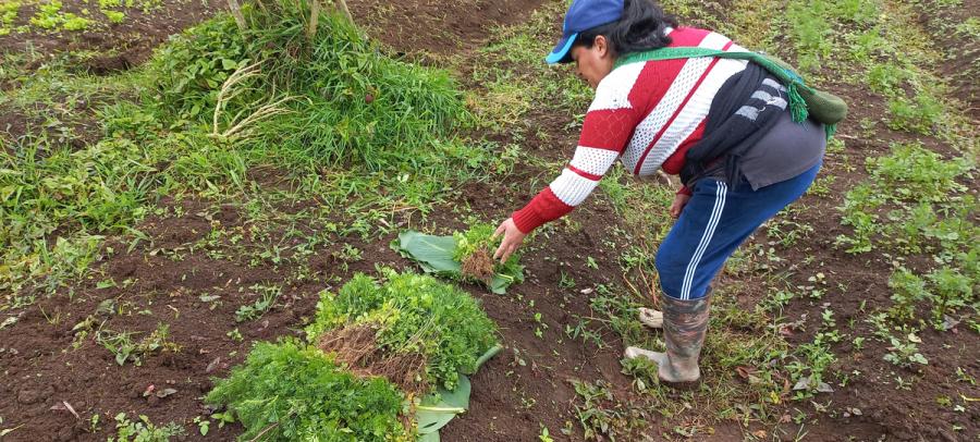
The photo on this page shows a detail of the first Miskito-made map of their sea territories. To make it, the Miskito captains used GPS to locate the centers of the major reefs. Next Miskito scuba divers swam the underwater reef edges towing a buoyed line which was followed by a mapping team with a GPS in an inflatable dinghy. GPS locations were taken and later down-loaded into a laptop computer to produce an outline of the reef. Miskito place names were recorded. The last draft of the map was made in the communities on September 24-25, 1994 at a seminar with the captains from each of the 13 communities (see photo on previous page). The map was then checked against aerial "videomaps" made earlier from Hi-8 tapes taken from a light aircraft of the sea territories. These taps were then played back in the communities on a 19" monitor. The reef images were freeze-framed and the captains wrote Miskito place names onto clear acetate taped to the monitor screen.
THE INDIGENOUS OCEAN
The Miskito traditional sea territories are one small link in a worldwide chain of indigenous sea territories. Indigenous ocean people live alongside mainland and island ocean waters and have livelihood and cultures adapted to the ocean. Much of the world's temperate and tropical mainland and island ocean waters have long been demarcated into the sea territories of resident indigenous marine tenure" (CMT), these ocean territories have proven to be one of the best means to conserve and sustainably use living marine resource (Johannes and Ruddle, 1985: Cordell, 1989). The simple secret to why customary marine tenure was a successful and worldwide conservation strategy - predating by centuries western fisheries management - is because it was the fishing communities themselves that controlled and regulated access to sea space and thus access to fragile sea resources, Through they promote sustainable use, many indigenous peoples' ocean territories have been eroded by wave after wave of colonial and post-colonial intrusions.
Indigenous peoples' surviving ocean territories are seldom recognized by national government, international organizations, or resource harvesting industries. Instead, external, centralized jurisdiction is imposed to give non-indigenous groups "rights" to indigenous ocean territorial waters and resources.
These external claims to indigenous sea territories are based on three common notions: 1) the European/Western notion that sea space cannot be claimed, tenured or owned by non sovereign peoples or groups; 2) the Western notion that all ocean space is a previously non-regulated, non-tenured, open-access "commons" whose resources would be ransacked if it were not for the top-down imposition of central government jurisdiction; and 3) the central state government notion that their maps are accurate and portray the only geography used by local communities and indigenous peoples.
At the same time, many indigenous peoples worldwide are engaged in the revolutionary undertaking of accurately mapping their own land and sea territories using the new geomatic technology of GPS and GIS, coupled to computers, video and film. The approach and objectives are very straightforward: defend the land and sea territories by accurately mapping them using new technology and traditional knowledge; use the maps to show the territories have been long occupied and managed which is why they are still biologically rich; and use the maps to internationally promote political decentralization as a geographic-territorial fact and the best means to conserve the planet's biological and cultural diversity. Because it is almost impossible to outlaw and prevent map making, this indigenous strategy is basically unstoppable. It effectively turns upside down the notions behind the maps that justify the intrusions.
MAP POWER
More indigenous territory has been claimed by maps than by guns. This assertion has its corollary: more indigenous territory can be reclaimed and defended by maps than by guns. Whereas maps like guns must be accurate, they have the additional advantages that they are inexpensive, don't require a permit, can be openly carried and used, internationally neutralize the invader's one-sided legalistic claims, and can be duplicated and transmitted electronically which defies all borders, all pretexts, and all occupations.
On a day-to-day basis, intrusions, invasions and occupations of indigenous people's land and sea territories are nationally and internationally justified by making and remaking maps and then conditioning people to accept them. Until recently, almost all maps were made by invading and occupying powers; however, this is rapidly changing as indigenous peoples are making and distributing their own maps using new technology that is much less expensive and much more accurate than the old technology that was once totally controlled by the map-making powers who used it to lay claim to indigenous nations' lands and waters.
For the cost of sending a small group of indigenous leaders to an international forum on territorial rights, a thousand maps of that nation's territory could be mailed of faxed worldwide. If it is well-designed, that map will have transcendental power because it can be easily translated by everyone everywhere; it transcends literacy; it is visually comprehensible' it can be a more powerful national symbol than a flag or an anthem; its creation reinforces group cohension (one cartographer is a technician while a community of cartographers is a force); and it provides strong credibility to its producers.
Such a map can only be challenged by another map, and the effectiveness of the challenge is based on the geographic authenticity of the map makers. A map of homelands or homewater automatically makes all other maps - be they antecedent or subsequent - subject to suspicion because they are made by the occupier's cartographers. Internationally, a people with a map of their territory/country/nation are far ahead in making their case for self-determination/autonomy confederation than are a people who have to locate themselves of their invader's map. Thus, an indigenous people's map helps to authenticate traditional territory, calls into question a central government's assertion that indigenous people don't have a land or sea territory, and serve internationally to promote greater self-determination.
Article copyright Cultural Survival, Inc.