For some time now land use planners have been using sketch mapping and participatory rural appraisal as tools for land use planning, community development planning, and resolving land use conflicts with indigenous communities in Asia. Once the task of expert consultants and government extension officers, local NGOs are now developing the skills to be able to make accurate maps themselves and to train community members to do much of the fields surveying interviewing, and map drawing.
On many official maps in Thailand, Malaysia, Indonesia, and Papua New Guinea, whole villages are missing or drawn in the wrong location. Indigenous communities are starting to make their own maps to say, "We are here, we exist, and our history and culture are written on the landscape." Maps also help demonstrate the rationality and sustainability of their traditional systems for resource use and tenure.
Recently, local NGOs have sponsored a series of workshops that teach practical mapping techniques,including map reading, using maps, compass and field surveying for locating features on a map; interviewing with maps; referencing photographs to maps; and manual map drafting. The fundamentals of these skills map drafting. The fundamentals of these skills are not complex. what is challenging is learning how to put these techniques together in a process that fits each unique landscape, cultural group and land use system, and to use these western-derived techniques to create a map that is both scientifically accurate and a correct reflection of local perception.
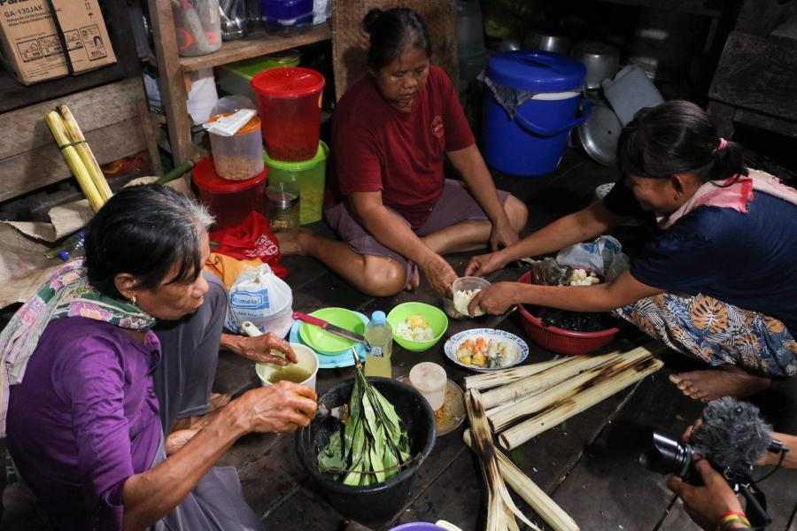
Making maps brings together community members, old and young, to actively communicate about the land. IN the end, the process can be a so important as the resulting maps. Depending on the community organization, the process may be different. In Thailand, an NGO had formed a small inter-tribal team of university students who help villages do mapping on request. In Indonesia, a village undertakes the mapping when one of its members has been trained to lead the process. Some of the local indigenous NGOs link with larger international conservation NGOs to use technologies such as Global Positioning System (GPS) and Geographic Information Systems (GIS). Most want to first ground their work with a solid understanding of manual map-making techniques. They are concerned about keeping the mapping process accessible to local community members and elders who will always be the main source of information and guidance.
For mapping activities to engage local people, they need to be able to understand it, or at least most if. Starting with villagers drawing their own picture, then building on that, takes some of the mystery out of maps for them. It gives them confidence to participate further, acknowledges the validity of their perception of the land, and clarifies what is most important to them. A session might involve a small group gathered in the village in the evening. A younger person, confident with using a pen, does the drawing with the close guidance of an elder, and with questions and corrections offered by the others in the group. Typically, they choose to sketch the river or road system as a frame, with the major river drawn first, drawing in and naming the small tributaries (even dry gullies) in perfect order. They draw the name and position of the peaks at the headwaters of each river, and draw the roads according to where they cross or follow the rivers. A discussion may enuse about the relative size, position and angle of the small creeks as villagers continue to correct and add detail, voicing a collective "ahhhhh" when the drawing finally looks right. These sketches (on paper or on 15x15 metre renderings on the ground) are used in subsequent discussion and referred to throughout the mapping process.
The next step is to take that sketch and transfer it onto a base map with scale, orientation, and grid reference - ideally a topographic map. Various basic field surveying techniques are used for this. However, availability of suitable topographic maps is a problem. In many cases the largest scale available is 1:250,000, a scale that shows only the main rivers. Where topographic maps are unavailable, or on flat coastal lands where the topography doesn't offer a frame, a base map must be created using GPS or surveying.
The more complete the base-map with natural features marked in local names, the more fruitful is the process of creating thematic map layers of local knowledge. On photocopies of the base map, or on sheets of tracing paper, maps are drawn showing locations of sacred sites, fruit tree and rattan groves, swidden rice fields (and their rotation), hunting areas, forest plant gathering areas, and traditional boundaries. Small groups of forest farmers gather in the evenings after a hunt or tending to their fields and huddle around a kerosene lamp to record every site they have cleared to plant rice over the last 20 years. Villagers may walk with an NGO mapping team during the day to point out their tree orchards and rattan plantations, where they have collected forest products, and their significant cultural and sacred sites.
The priority thematic information depends on the culture landscape, and the current situation for each community, In outer island Indonesia many communities use maps to communicate about their traditional laws, called add, which are oral traditions, that guide their system of land use, resource regulations, and customary ownership. Adat systems are recognized in the INdonesian constitution, but not in forest management policies. Maps support research that shows adat systems play an essential role in forest conservation and sustainable land use. An immediate use for maps is to record the location of fruit tree and rattan plantations and gravesites that are protected under the Forest Act, and the location of traditionally protected forest areas that often have no legal protection.
The tribal peoples of North Thailand use maps to communicate a different situation. They have a shorter history to depict in that locale. Nonetheless, their maps dispel the myth of rapacious shifting cultivation by describing a stable, complex rotational system of swidden cultivation and forest use, driven by a distinct culture with a strong connection to the land expressed in a dense pattern of cultural and sacred sites.
Maps help local indigenous peoples to prove to government land use decision-makers that they are the most responsible stewards of the environmentally critical mountain watersheds of north Thailand, the delicately balance swamp forests of Papua New Guinea, and the richly diverse rainforests of outer island Indonesia.
Article copyright Cultural Survival, Inc.